Snowfield Model of Mt. Olympus, Utah
Adam Wehmann
Fall 2011
Introduction
The spatial distribution of snow cover on exposed mountainous terrain is primarily determined by the interaction between topography and wind. The principle of airflow continuity, which describes how wind speeds change due to flow constriction and expansion, and flow separation theory, which describes the interactions of wind streamlines with local relief when a predominantly directed strong wind is present, offer suitable bases for the development of models.
Study Area
Mt. Olympus is located in Salt Lake County, Utah in the Wasatch Mountain Range. It has an elevation of 2,751 m and a prominence of 118 m. Its peak is raised approximately 1460 m above the Salt Lake Valley and, therefore, is quite visible from anywhere in the area. From the middle of November to early June, the mountain is usually covered with snow.
Data
| Name | Data Source | Projection | Theme |
|---|---|---|---|
| Salt Lake County 2m Contour Shapefiles | Utah GIS Portal | NAD 1983 UTM Zone 12N | contour elevation data derived from LiDAR |
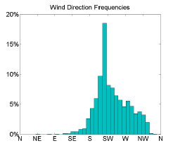
| Cardiff Peak (IFF) meteorological station wind data | MesoWest Data Server | none | wind speed and direction data from nearby monitor |
| Photographs of Mt. Olympus | Michael Madsen | none | validation data |
Methods
Contour data was used to produce 2 and 10 meter DEMs in TIFF format for the study area. Two algorithms were written in MATLAB to process the DEMs based on the snow accumulation and transport approach of Ishikawa and Sawagaki (2001) and the snow redistribution approach of Winstral, Elder, and Davis (2002).
The approach due to Ishikawa and Sawagaki involved raising the elevation of the center cell in a moving window by a proportion of its difference with the maximum elevation in the neighborhood. This proportion was determined by transformations of aspect and slope to account for ablation based on the frequency of wind direction and accumulation based on steepness of the terrain.
 The approach due to Winstral et al. involved locating the steepest slope breaks along vectors in nearby and outlying terrain in an
upwind wedge-shaped neighborhood. The degree of shelter or exposure of each cell was indexed by the mean vertical angle to nearby breaks,
while the potential for flow separation was indexed by the difference between that angle and the mean angle from the nearby to outlying breaks.
Areas that snow drifts may form in were delineated by the potential for flow separation and the shelter given by outlying terrain.
The approach due to Winstral et al. involved locating the steepest slope breaks along vectors in nearby and outlying terrain in an
upwind wedge-shaped neighborhood. The degree of shelter or exposure of each cell was indexed by the mean vertical angle to nearby breaks,
while the potential for flow separation was indexed by the difference between that angle and the mean angle from the nearby to outlying breaks.
Areas that snow drifts may form in were delineated by the potential for flow separation and the shelter given by outlying terrain.
Results
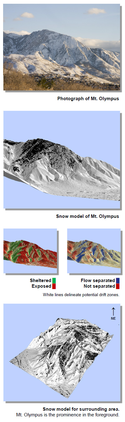
Because ground truth snow depth data was not available for this project, the use of the models was limited to the qualitative depiction of potential snow cover and drift zones. This limitation is inherent in the approach due to Ishikawa and Sawagaki but not in Winstral et al., which may be extended to predict snow depths when in situ data is available. As such, visual comparisons of the model results with photographs of the mountain were used to validate the approaches. The results were that the spatial distribution of snow generally corresponded with reality.
References
- Ishikawa, M. & Sawagaki, T. 2001. GIS-simulation of the spatial distribution of snow cover and observed ground temperatures in the Daisetsu Mountains, Japan. Norsk Geogra. sk Tidsskrift-Norwegian Journal of Geography, 55, pp. 212-218.
- Winstral, A., Elder, K., Davis. R.E. 2002. Spatial snow modeling of wind-redistributed snow using terrain-based parameters. Journal of Hydrometeorology, 3, pp. 524-538.