Time Geography Visualization
Space-Time Prisms
Downloads:
- Files (script and example)
Problem
Space-time prisms (STPs) allow the visualization of individual actor's ability to move through space in an intuitive way. They are commonly employed in time geography research and have applications in studies of transportion and accessibility. The 3D shapes used to model space-time interactions allow these interactions to be quantified and studied.
Presented here is a script to visualize a particular type of STP in shapefile format for use in ArcScene. The script was developed in response to an inquiry on my department's listserv.
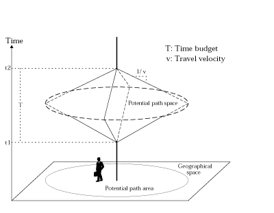
Illustration source: Wu and Miller 2001.
Results
The Python script uses ArcPy functionality to read a point shapefile containing entities for which to generate prisms. Each entity has attributes denoting its travel budget and velocity as defined in the illustration above, which together constrain the shape of the prism. Prisms are generated for each site and written to a 3D polygon shapefile.
References
Wu, Y-H., H. J. Miller. 2001. Computational tools for measuring space-time accessibility within dynamic flow transportation networks. Journal of Transportation and Statistics 4(2/3), pp. 1-14. Available here.